GEOTECHNICAL ENGINEERING
HUNTSVILLE
HomeGeophysicsSeismic tomography (refraction/reflection)

Advanced Seismic Tomography for Subsurface Characterization in Huntsville

Geotechnical engineering with regional judgment.

LEARN MORE

The first time we mobilized a 48-channel seismograph across a limestone outcrop near Monte Sano, the client expected uniform bedrock at 12 feet. The refraction tomography told a different story entirely: a deep paleokarst sinkhole masked by just three feet of residual clay, invisible from the surface. Huntsville sits squarely on the Mississippian-aged Tuscumbia Limestone and Fort Payne Chert formations, where dissolution features can create erratic rockhead profiles across a single building footprint. Standard borings spaced at 50-foot intervals routinely miss these features — a single drill hole hits solid rock while the next one encounters 30 feet of collapsed cavity fill. Our tomography surveys generate continuous P-wave and S-wave velocity cross-sections that reveal these hidden hazards before excavation begins. For deep foundation design on the city's rapidly expanding research park campuses, we often combine the velocity model with SPT drilling data to calibrate rock mass modulus against N-values.

A P-wave velocity tomogram across Huntsville's karst terrain can reveal a hidden dissolution cavity that 20 standard borings might miss — and that single feature can redefine the entire foundation strategy.
Our service areas

Process and scope

A recurring mistake we see on Huntsville job sites involves relying exclusively on surface mapping to characterize subsurface rippability. A contractor may assume weathered limestone can be excavated with a hydraulic hammer based on outcrop appearance, only to encounter massive, unweathered ledges three feet down. The seismic refraction and reflection tomography method resolves this by measuring seismic velocity gradients — not just a single interface depth. We deploy multiple shot points along linear or fan arrays, then invert the travel-time picks using ray-tracing algorithms that account for lateral velocity variations. The resulting 2D tomogram distinguishes between residual soil (Vp < 1,200 m/s), highly fractured rock (1,200–2,500 m/s), and competent limestone (Vp > 3,000 m/s). For sites with suspected deep cavities beneath Cummings Research Park expansions, we integrate the tomographic data with MASW surface-wave profiling to constrain Vs30 for IBC seismic site classification.
Advanced Seismic Tomography for Subsurface Characterization in Huntsville
Technical reference — Huntsville

Local geotechnical context

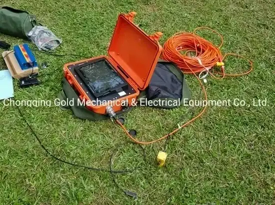
The field setup for a tomographic survey on a Huntsville hillside involves laying out a spread of 24 or more geophones, each planted firmly into the stiff red clay that blankets much of the Tennessee Valley. If a single geophone loses coupling — common on dry, fissured clay or loose chert gravel — the entire travel-time dataset gets compromised, producing artifacts in the velocity model that could be misinterpreted as a cavity or fracture zone. Our crew checks coupling with hammer taps at every station before firing the full shot sequence. The bigger operational risk involves ambient noise: a survey conducted 500 feet from an active quarry blast or heavy earthmoving equipment introduces high-frequency noise that masks first-arrival picks. In those conditions, we switch to a stacked vertical-hammer source and acquire multiple records per shot point to improve signal-to-noise ratio. At sites where steep topography creates irregular shot-receiver geometries, we process the data through a 3D refraction tomography routine to avoid the severe velocity smearing that a 2D assumption would produce.

Need a geotechnical assessment?

Reply within 24h.

Email: contact@geotechnical-engineering1.org

Reference standards

IBC 2021 Section 1613 — Seismic ground motion and site classification (Vs30 determination), ASCE/SEI 7-22 Chapter 20 — Site classification procedure using shear wave velocity, ASTM D5777-18 — Standard Guide for Using the Seismic Refraction Method for Subsurface Investigation, ASTM D7128-18 — Standard Guide for Using the Seismic Surface Wave (MASW) Method, FHWA NHI-05-037 — Geotechnical site characterization guidelines (seismic velocity for rippability assessment)

Technical data

ParameterTypical value
Geophone array configuration24 to 48 channels, 5–10 ft spacing typical per local bedrock variability
Energy source8–16 lb sledgehammer on aluminum plate; weight drop or accelerated weight drop for deeper targets
Maximum investigation depth (refraction)80–120 ft depending on array length and velocity contrast
Typical P-wave velocity range in Tuscumbia Limestone3,200–5,800 m/s for competent rock; <1,800 m/s in fractured or karst-weathered zones
Tomographic inversion algorithmNon-linear least-squares (damped SIRT) or WET with finite-difference ray tracing
Data acquisition standardASTM D5777 for seismic refraction; supplement with D7128 for surface wave where applicable
Common target resolution in karstDetectable cavity diameter ≥ 1/3 of geophone spacing at depth of interest

Questions and answers

How deep can seismic refraction tomography see in Huntsville's limestone terrain?

The investigation depth depends on the geophone spread length — typically 3 to 5 times the spread length for a refraction survey. With a 240-foot array and a sledgehammer source, we routinely achieve penetration to 80–120 feet in competent Tuscumbia Limestone. For deeper targets, we deploy an accelerated weight drop source that extends investigation depth to approximately 200 feet. Reflection profiling can reach greater depths when refraction is limited by a velocity inversion layer.

What does seismic tomography cost for a typical commercial building site in Huntsville?

A standard 2D seismic refraction tomography survey for a commercial building footprint in the Huntsville area typically falls between US$2,830 and US$5,880, depending on the number of profile lines, geophone spacing, and whether P-wave only or both P- and S-wave data are acquired. Sites with dense vegetation requiring line-cutting or steep slopes requiring roped access will trend toward the upper end of the range.

How does seismic tomography compare to MASW for determining site class?

Both methods measure shear-wave velocity, but they sample different volumes of the subsurface. MASW provides a 1D Vs profile beneath the array center, averaged horizontally — ideal for Vs30 calculation. Refraction tomography produces a 2D cross-section that captures lateral variations in velocity. On Huntsville's karst terrain, where rockhead can vary 30 feet across 100 horizontal feet, we recommend running both surveys and integrating the results: MASW for the IBC site class determination, tomography for identifying the exact location and geometry of cavities or fracture zones.

Can seismic tomography detect sinkholes before they collapse?

Yes — this is one of the primary applications for tomography in the Huntsville area. Active dissolution cavities and raveling zones show up as low-velocity anomalies (Vp below 1,800 m/s) within otherwise high-velocity limestone. The method detects air-filled, water-filled, and clay-filled cavities, though the velocity contrast is strongest for air-filled voids. We have identified paleokarst features as small as 5 feet in diameter at depths of 40 feet using a 5-foot geophone spacing. Pairing tomography with resistivity imaging improves discrimination between a water-filled cavity and a clay-filled sinkhole.

What permits or access restrictions apply to seismic surveys in Huntsville city limits?

Seismic refraction and reflection surveys are non-invasive surface methods, so they generally do not require excavation permits. However, if the survey crosses a public right-of-way, a right-of-way permit from the City of Huntsville Engineering Division is necessary. For surveys on properties adjacent to Redstone Arsenal, we coordinate with the installation's environmental office regarding any access or noise restrictions. Most private commercial sites require only landowner permission, and our crew carries full liability insurance documentation.

Location and service area

We serve projects in Huntsville and surrounding areas.

View larger map