GEOTECHNICAL ENGINEERING
HUNTSVILLE
HomeGeophysicsElectrical resistivity / VES (Vertical Electrical Sounding)

Electrical Resistivity Surveys and VES in Huntsville, AL

Geotechnical engineering with regional judgment.

LEARN MORE

The 2024 Alabama Building Code, referencing the IBC and ASCE 7 standards, places a strong emphasis on understanding subsurface conditions before committing to a foundation design. In Huntsville, where the geology shifts dramatically from the limestone karst of the Appalachian foothills to the deep residual soils of the Tennessee River Valley, a standard borehole program often leaves critical gaps in the subsurface profile. Electrical resistivity testing, and specifically Vertical Electrical Sounding (VES), fills those gaps by imaging the ground's electrical properties. Our team applies ASTM D6431 methodology to differentiate between competent bedrock, water-filled cavities, and clay-rich overburden without disturbing the site. We have found this geophysical approach particularly valuable on the city's eastern expansion corridors, where the Monte Sano escarpment creates complex subsurface drainage patterns that directly influence foundation performance and long-term structural integrity.

In karstic limestone like Huntsville's, resistivity isn't just about soil type—it's a direct indicator of dissolution voids that mechanical borings can completely miss.
Our service areas

Process and scope

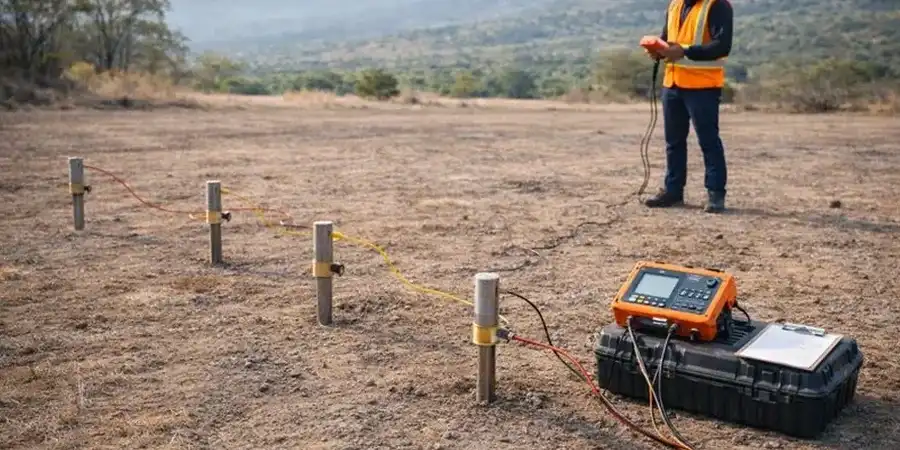
Contrasting the soil regimes across Huntsville reveals why a single investigation method rarely suffices. In the downtown and Five Points historic districts, we frequently encounter shallow limestone bedrock with epikarst development—solutionally enlarged fissures that create abrupt vertical resistivity contrasts. A few miles west, toward the Research Park Boulevard corridor and the Redstone Arsenal buffer zone, the profile transitions to thicker sequences of alluvial terrace deposits where the water table and clay content control the resistivity signature. Our VES arrays, typically deployed in Schlumberger configuration with maximum AB/2 spacings reaching 150 meters, allow us to model these transitions in two dimensions. When the resistivity data suggests a buried irregular bedrock surface, we often recommend supplementing the geophysical survey with targeted test pits to calibrate the electrical boundaries against direct visual observation of the strata, which sharpens the accuracy of the geotechnical model considerably.
Electrical Resistivity Surveys and VES in Huntsville, AL
Technical reference — Huntsville

Local geotechnical context

Huntsville's rapid growth, pushing the metro population past 500,000, means construction is expanding onto terrain historically considered marginal—particularly slope faces and karst plains where the 2011 Mineral, Virginia earthquake, though distant, reminded local engineers that even intraplate seismic zones transmit energy unpredictably through variable overburden. The primary risk from undiscovered subsurface voids or saturated clay lenses isn't just excessive settlement; it's differential movement across a single structure footprint. A VES survey pinpoints low-resistivity anomalies that correspond to zones of high moisture content or clay infilling within the limestone, which are precisely the areas where foundation support will vary most. Ignoring these lateral heterogeneities can lead to structural distress that no amount of over-engineering in the slab can rectify after the fact.

Need a geotechnical assessment?

Reply within 24h.

Email: contact@geotechnical-engineering1.org

Reference standards

ASTM D6431-18 Standard Guide for Using the Direct Current Resistivity Method, IBC 2024 / Alabama Building Code Chapter 18 (Soils and Foundations), ASCE 7-22 Minimum Design Loads and Associated Criteria, USACE EM 1110-1-1802 Geophysical Exploration for Engineering

Technical data

ParameterTypical value
Standard MethodASTM D6431-18 (DC Resistivity)
Primary Array ConfigurationSchlumberger (Vertical Electrical Sounding)
Typical Depth of Investigation15 to 60 meters (extendable with L-Array)
Measured ParameterApparent Resistivity (Ohm-m)
Output Deliverable2D/3D Resistivity Inversion Models & Depth Profiles
Electrode Spacing RangeAB/2 up to 150 m standard
Data Processing SoftwareRES2DINV / EarthImager 2D

Questions and answers

How much does a VES resistivity survey typically cost for a standard lot in Huntsville?

For a typical residential or light commercial site in the Huntsville area, a VES investigation with three to five soundings and a basic interpretation report generally runs between US$620 and US$950. The final figure depends on access conditions, the required depth of investigation, and whether 2D tomography lines are needed in addition to point soundings. We provide a firm quote after reviewing the site's topography and any existing geotechnical data.

What depth can Vertical Electrical Sounding reach in our local limestone geology?

The depth of investigation in Vertical Electrical Sounding is controlled by the maximum current electrode separation (AB/2). In Huntsville's residual clay over limestone environment, we typically achieve reliable resistivity models to depths of 50 to 60 meters when we extend the AB/2 spacing to 150 meters. The actual depth of resolution will depend on the resistivity contrast between the overburden and the bedrock; high-contrast boundaries image more sharply.

Can resistivity testing distinguish between a dry void and a clay-filled cavity in the limestone?

Yes, that distinction is one of the method's strengths in karst terrain. An air-filled dissolution cavity will present as a high-resistivity anomaly because air is an electrical insulator, whereas a clay-filled or water-saturated cavity will show as a pronounced low-resistivity zone relative to the surrounding competent limestone. We calibrate these signatures using local boring logs where available to refine the material-type interpretation.

Location and service area

We serve projects in Huntsville and surrounding areas. More info.

View larger map